
On December 24, 1968, Apollo 8 emerged from its fourth lunar cycle on the first manned mission to another celestial body. “Oh, my God,” cried astronaut Frank Borman as the spacecraft emerged from the moon’s dark side. “Look at that picture over there! Here’s the Earth coming up! Wow, is that pretty.” Crew member William Anders grabbed a modified Hasselblad camera and shot what has become an iconic photograph. In countless reproductions, Earthrise depicts our planet in the distance, a blue-and-white spot rising above a cratered and ashen lunar landscape, set against the blackness of space.
Laura Kurgan’s Close Up at a Distance: Mapping, Technology, and Politics opens on a reproduction of Earthrise and of another iconic image of Earth, the Blue Marble photograph, shot four years later from Apollo 17. These two pictures are some of the most widely reproduced in history. In the popular imagination, they’ve become synonymous with the environmental movement, underlining the fact that, in the grand scheme of things, we live on a small, isolated, and fragile planet. But the pair of images are also emblematic of something else: the dawn of what historian Benjamin Lazier calls the “Earthrise Era.” We are now deep within this revolutionary moment—pictures and dynamic maps generated from space-based platforms are a part of our everyday lives. Since mapping technologies first began trickling into consumer products such as GPS navigation systems and smartphones, the view from above has become so ubiquitous that we seldom reflect on it. “We do not stand at a distance from these technologies,” Kurgan writes, “but are addressed by and embedded within them.”
Kurgan, the director of the Spatial Information Design Lab and an associate professor of architecture at Columbia University, is intimately familiar with mapping technologies and their role in shaping how we look at the world. She is especially critical of the false sense of objectivity and omniscience that modern mapping devices typically convey. In her opening chapter, Kurgan observes that although overhead imaging holds out the promise of a transparent, open, and accessible world, it actually delivers something exceptionally specific and limited. From Google Earth, for example, we can see the streets of Istanbul and Kuala Lumpur but cannot hear the particular sounds of each city—or experience its smells, clumsily order food in a foreign language, bump into a stranger on the street, or get lost in serpentine alleys.
Imaging technologies, explains Kurgan, “let us see too much, and hence blind us to what we cannot see, imposing a quiet tyranny of orientation that erases the possibility of disoriented discovery.” Part of the problem is a matter of perspective: The view from above is less an expansive panorama than a view through a keyhole. This vantage is also highly susceptible to ideological forces. When Colin Powell sat before the UN advocating the invasion of Iraq, he brought satellite images showing a handful of trucks and buildings. This data, he claimed, provided evidence of “active chemical munitions bunkers” operating outside Baghdad. “The facts speak for themselves,” he said. Of course, as Kurgan points out, the images did anything but that, and Powell needed to do a great deal of misleading speaking on their behalf to make them show anything close to what he claimed they did.
But Kurgan does not want to write off the “visual regime” of satellite imagery entirely. In fact, much of her work makes use of visual data culled from mapping, geolocation, and overhead-imaging technologies, and in Close Up at a Distance she argues that the need for interpretation is precisely what makes this kind of information so significant. For her, the “imaginative leaps” required to turn data into stories don’t always have to be carried out by the Colin Powells of the world: Such interpretive work can also advance movements for social justice or anti-imperial politics—such as when Pakistani journalists used Google Earth to document an unacknowledged American Predator-drone base in Baluchistan. In a series of deftly rendered case studies, Kurgan demonstrates how understanding satellite images—their production, interpretation, and distribution—is “a civic responsibility and a political obligation.”
Many of Kurgan’s projects bring a political dimension to what at first glance looks like abstract art. In her installation You Are Here, 1994–95, reprinted and discussed in the first chapter of the book, Kurgan uses GIS and GPS technologies to draw virtual letters, lines, and meandering routes through the digital depictions of space produced by military targeting satellites. These playful digital dérives, which recall Situationist psychogeographies, seek to appropriate and perhaps détourne the “will to map” underlying the technologies she employs. In a 2004 work, Kurgan draws upon the abstract paintings of Ellsworth Kelly to produce a series of four monochromatic photographs titled White, Blue, Green, and Yellow. These images are in fact satellite photographs of the Arctic National Wildlife Refuge, the Atlantic Ocean, old-growth forests in Cameroon, and the southern desert in Iraq, and closer inspection reveals that they’re also sites of social conflict: Illegal logging is taking place in the old-growth forest, and a pair of American military helicopters hover over the Iraqi desert. Upon reading the captions, we learn that the image of Alaska portrays an area that drew popular protests over oil drilling, and the photo of the ocean depicts the intersection of the Greenwich meridian and the equator—an arbitrary spot on the map that nonetheless anchors the system of Earth coordinates used for mapping.
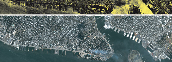
Kurgan continues her voyage through the ethical labyrinth of mapping technologies with additional studies of pre- and postapartheid Cape Town, mass graves in Kosovo, and post-9/11 Manhattan. She ends the book with an account of her most ambitious use of mapping technologies, the Million-Dollar Blocks project, 2005, which involved creating an alternative to crime “hot-spot” maps, such as those produced by the NYPD’s COMPSTAT (“computerized statistics”) software. Inspired by the early work of Eddie Ellis, who created a “prisoner’s ‘think tank’” to analyze the demographics of incarceration while serving a twenty-year sentence, Million-Dollar Blocks visualizes the “microgeography” of mass imprisonment by color-coding blocks of New York City neighborhoods by their incarceration rates. The visualizations highlight remarkable facts about the criminal-justice system, including that the vast majority of imprisoned persons come from an astonishingly small number of neighborhoods, and primarily from particular blocks within these neighborhoods. Kurgan argues that the transfer of individuals from urban centers to hinterland prisons constitutes a mass migration of sorts, with rural prisons forming a “distant exostructure of many American cities today.” The project is a powerful critique of mass incarceration, one that requires viewers to consider the specific geographies behind it. By slightly changing the conventions that police and politicians use to visualize crime, Kurgan creates a vantage point that reveals a radically new understanding of crime, poverty, and imprisonment.
All of which brings us back to Earthrise. For all of its ubiquity, it’s actually one of the most incorrectly reproduced photos in history. In most versions, the image shows the moon’s surface as a horizontal line, with Earth “rising” in the familiar orientation of a sunrise or sunset. But the print hanging on Bill Anders’s wall is very different. Instead of displaying a flattened-out horizon line, Anders’s print shows the moon’s horizon with a vertical orientation—the view that Apollo 8 saw from an equatorial orbit. The “corrected” perspective of Earthrise doesn’t conjure the quasi-religious feeling that’s usually associated with the image. The vertical horizon makes it seem, well, alien. This small empirical adjustment underlines the strangeness of the image’s vantage point. This, perhaps, is the Earthrise that Kurgan teaches us how to see: an overhead view of the planet, to be sure, but one that is slightly uncomfortable. This is not a view that someone can attempt to understand at first glance, but one of a person seeing the world with new eyes.
Trevor Paglen is an artist whose most recent book is The Last Pictures (University of California Press, 2012).


