

IN 2010, Richard Misrach returned to photograph the stretch of Louisiana known as Cancer Alley, a 150-mile section of the Mississippi River between New Orleans and Baton Rouge, which he had also explored in 1998. The area is home to petrochemical plants that have polluted the river and spoiled the environment for years. But Misrach’s Petrochemical America is more than a disheartening photographic essay on the evils of Dow Chemical. Along with ashy skies and cloudy rivers, we see plantation tour guides and the restored slave cabins they show visitors, ramshackle churches, tankers and fishing ships on the Mississippi, rickety roadside signs, and trailer homes in the shadow of natural-gas tanks.
Misrach’s view is mainly detached, favoring an objective-ish style free of “decisive moments,” recalling the work of Bernd and Hilla Becher, Andreas Gursky, and the many flat-affect photographers influenced by the Düsseldorf school. Part 2 of the book takes an analytical turn with landscape architect Kate Orff’s “Ecological Atlas”: a collection of maps, charts, time lines, and graphs that track and explain the economic and environmental forces at work in places such as Cancer Alley, and speculate about what, exactly, the grim future will look like.
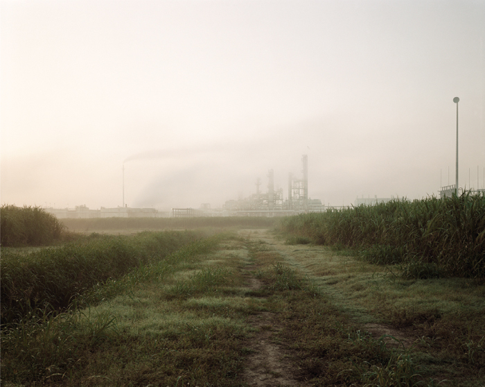
Sugar Cane and Refinery, 1998 (above), depicts a no-man’s-land oversaturated with gloom and dread—pure True Detective territory, sans Woody Harrelson and gratuitous nudes. Unlike the HBO show, though, Misrach is not content to simply drop us in a moody landscape and let us stew in juicy angst. Here, the photo works in concert with Orff’s atlas and the book’s images of bridges, antebellum relics, Texaco stations, decrepit lots, and the like, creating a kind of systems novel of the poisoned American South. The atmosphere is suffocating, to be sure, and Misrach asks us to breathe it in as deeply as we can.


